


- Technology
- Mapping / Spatial Analysis Software
- MapInfo Professional v11.0 Features
- Data Sources
- Languages and Environments

MapInfo Professional v11.0 Features
Summary
MapInfo Professional v11.0 is an industry leading location intelligence desktop solution used for creating, editing, visualizing and analyzing customer and business data in the context of location.
Benefits
• Saves time and resources with a new interface, reducing clicks, clutter, and effort
• Promotes cost efficiency through improved data access
• Supports a wide variety of data types and formats, including PostGIS and Microsoft® SQL Server 2008 databases
• Maximizes investment in Microsoft Office®
• Produces better looking maps to facilitate strategic planning efforts
• Provides easier access to proportion overlap capabilities, as well as increased performance
Overview
MapInfo Professional v11.0, the powerful new release of Pitney Bowes Business Insight’s leading desktop mapping application, represents a new standard of usability in location intelligence solutions. MapInfo Professional v11.0 provides an assortment of dynamic new features, including a powerful user interface, enhanced data access, and robust map output capabilities. The new browser window offers advanced data entry options and follows the latest industry practices that result in simple yet effective data entry.
Redesigned Browser Window
MapInfo Professional v11.0 simplifies tabular data entry, editing, navigation and analysis. The new browser window offers advanced data entry options using the latest industry practices for easy and effective data entry. Alternating row color control, plus easy control over font size and color ensures improved data readability.
Perform Memory Intensive Operations with Enhanced 64-bit Support
MapInfo Professional v11.0 now supports the 64-bit Windows operating environment. MapInfo Professional v11.0 automatically detects and utilizes up to twice the memory space of previous versions. Performing such operations as: object processing, Large Grid, MS Excel and Raster data loading and contouring can now work with twice the amount of data without memory limitations or program errors.
Powerful User Interface
MapInfo Professional v11.0’s flexible user interface not only greatly improves efficiency and organization, but also increases productivity. The user interface allows users to dock toolbars on all four sides of the application helping to improve efficiency, reduce screen clutter, and save time.
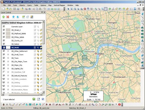
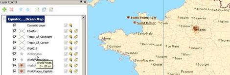
Flexible Layer Control
MapInfo Professional v11.0 includes a powerful layer control. The Layer Control recently redesigned with release 10.0, shown as either a floating or docked window that remains visible during the entire mapping session, provides quick and easy access at all times. Style swatches, label conditions, and text style settings are now easily accessible and included next to each layer, allowing you to change and preview layer settings quickly and easily. By simply clicking the desired style swatch, the new style override can be set for one or more layers in a single step. The new layer property manipulation process, coupled with the immediate preview capability, results in fewer clicks and improved efficiency. The redesigned layer control not only allows access to layers in all open maps, but also allows editing to layers in multiple workspaces, simultaneously. By allowing you to view, manipulate, and preview all current map layers, MapInfo Professional v11.0 creates a substantial time savings.
Enhanced Data Access
Data access is essential to any and all analysis. By providing support for the latest industry standards and databases, MapInfo Professional v11.0 enables you to apply the power of location to an unlimited number of data types. Supported data formats include:
PostGIS—Provides full read and write capabilities to the open source PostgreSQL database. Access to the open source database allows users to access, edit, and save PostGIS files to the database through MapInfo Professional. MapInfo Professional v11.0 satisfies various government mandates requiring PostGIS format support.
Microsoft ® SQL Server 2008 Spatial Database—Optimizes IT investments by providing both read and write access to Microsoft’s ® SQL Server 2008 spatial database.
Microsoft ® Office 2007—Supports the latest format of both Microsoft ® Excel and
Microsoft ® Access.
Dynamic Map Output
MapInfo Professional v11.0 includes dynamic elements and map output capabilities, such as a dynamic scalebar and the ability to export maps to layered PDF. The dynamic scale bar automatically adjusts and updates as you zoom, pan, and resize the map window. Once the desired maps are created, MapInfo Professional v11.0 supports exporting maps to layered PDF format. The layered PDF format allows future access to the various layers of data. This enable specific layers to be turned on or off, depending on the requirement, providing flexibility for the end user.
MapInfo Professional Premium Services Ideal for users who require street level detail on their maps but who do not need the individual detailed layers. Up-to-date worldwide street mapping (Bing maps and Open StreetMap maps) available at the click of a button. Data sourced from major street vendors and is constantly updated.
Very inexpensive background mapping compared to licensing similar data products for in-house usage. This service avoids the need for users to manage and update their CDs or DVDs of data. Improves the ease of use of MI Pro
Includes access to an easy to use lookup utility (Move Map to…) to zoom your map to any place name, address or point of interest in the Bing service gazetteer. Background mapping is built right into MapInfo Professional. It is easily found and used by new and experienced users alike.