

Solutions
TSI enables both its public and private sector clients to implement an impressive range of solutions - from on-screen visualization using maps and location pinpointing to sophisticated wireless and web applications that enable customers to improve customer responsiveness, business process analysis, sales territory definition, gps tracking, route optimization, power outage impact and network planning. With over two decades of experience under its belt, TSI has emerged as specialists in the development of both mapping and spatial analysis solutions for public safety, communications and utilities and business continuity.Mapping
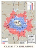
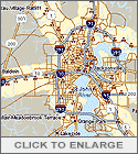
What types of information are the most meaningful to be mapped for your operations? Is it location of key assets, crime statistics, population density, or other demographics? Or is it real-time information, like the location of vehicles? Or perhaps it is a combination of static and real-time information if business continuity is your motivation. Chances are that the answer varies depending on your mission and even based upon the different roles individuals play in your organization.
|
|
TSI can also customize these layers of information to meet the needs of various personnel and deliver it in its most appropriate form - via a desktop PC, on the web, or through a wireless device. By customizing and extending MapInfo, or other popular mapping products to provide comprehensive solutions, TSI can deliver new insights into your organization, and can dramatically improve your planning, effectiveness, and overall productivity.
Spatial Analysis
 |
|